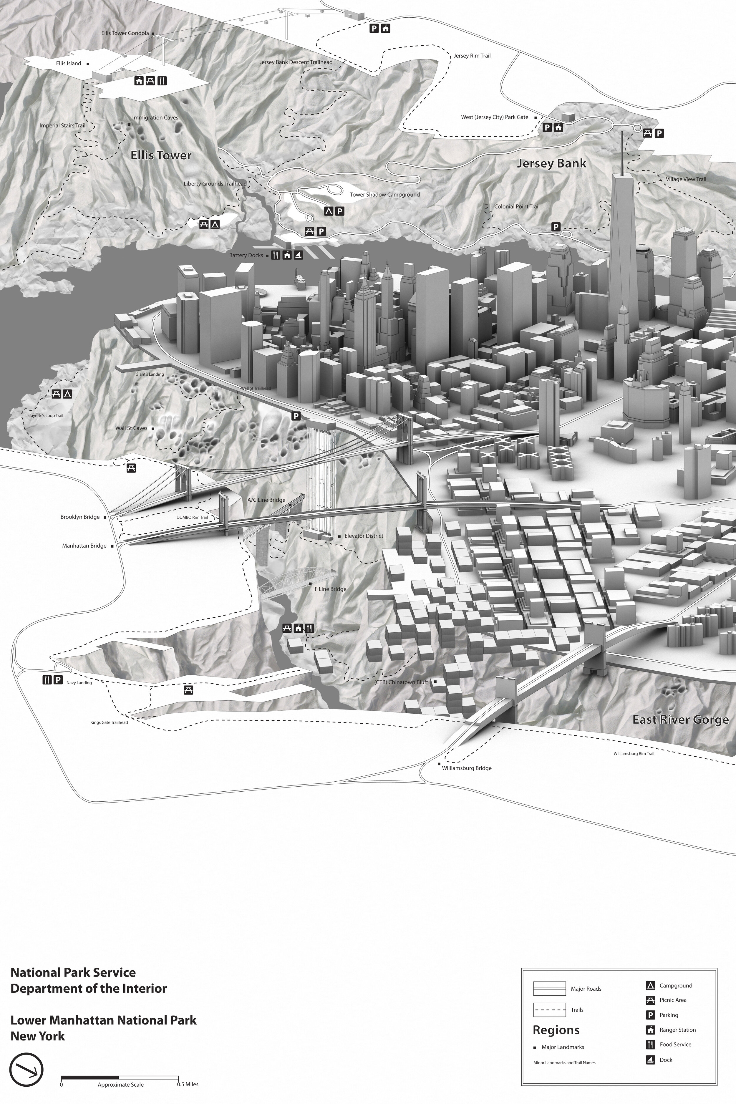
LOWER MANHATTAN NATIONAL PARK
2012 Collaboration with Geoff Manaugh | A trail map exploring Lebbeus Wood’s drawing Lower Manhattan. Created for an exhibit at Storefront for Art and Architecture.
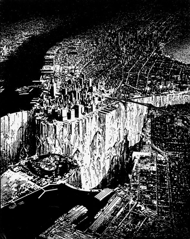
Invited to contribute to an exhibit at Storefront for Art and Architecture, Geoff Manaugh and myself were given Lebbeus Woods's image of Lower Manhattan. The image shows the East River drained, exposing a bedrock canyon running the cities edge. The rules required we not spend more than 10 hours on the image and that the accompanying text not exceed 400 words.
Our approach was to provide an explanation for the condition setup by Lebbeus Woods while simultaneously providing a look at how this new space is seen as an asset to the city. Our image is of a trail map for the newly formed Lower Manhattan National Park. The image and text describe how the city meets this new canyon and some of the geological features found within the park. (Right: Lebbeus Woods Original Drawing)
LOWER MANHATTAN NATIONAL PARK
In 2057, massive flood-control structures protecting New York City from the rising seas required a redirecting of the Hudson and East Rivers northeast, into Long Island Sound. The resulting dams—the construction of which triggered small earthquakes throughout New England—allowed for the draining of the old riverbed south and east of Manhattan, revealing the unearthly geological circumstances on which this archipelagic metropolis sits.
Following several years of scientific surveys into the mazelike gorges and intersecting cliffsides below—complex terrestrial forms previously buried by the waters and mud at the edge of the city—teams from the Army Corps of Engineers set about clearing the region from more than a hundred thousand years’ worth of silt and debris flowing down from the upper watershed. Even shipwrecks going back to the Colonial era were dredged, blasted, and removed—in some cases, the wrecks’ dried and re-kilned timber used to build houses elsewhere in the city.
The resulting reclaimed landscape of gorges, cataracts, caves, slopes, and arches was unlike anything seen in another city—as if the Grand Canyon had been discovered suddenly cleaving Shanghai in two. And thus a new National Park was swiftly declared: Lower Manhattan National Park, its name partially inspired by architect Lebbeus Woods, a New Yorker who explored the urban possibilities offered by damming the city’s rivers in a proposal back in 1999.
By 2076, the nation’s three-hundredth birthday, Lower Manhattan National Park was open to the public, encompassing hiking trails, campsites, interpretive routes, and modern visitors’ centers that unlocked the city’s depths for amateur exploration. For generations, bankers had no idea that, just off the fiscal cliff at the end of their well-known street, the Wall Street Gorges would soon loom, an extraordinary district of trails smelling vaguely of sea salt; or that, within walking distance of Chinatown, switchbacks would lead steeply down into the shadows of a marine void off the Lower East Side. There are the Hudson Caves; the Brooklyn Bridges (a nest of suspension bridges spanning boroughs); Governors Tower (formerly Governors Island); and, of course, the New Wall—the East River Dam itself—now an athletic attraction to people all over the world, lined with climbing routes and ornamental handholds.
New Yorkers once fearful of the rising waters of climate change now look down into vast canyons surrounding the city, lined with historic plaques explaining how this newest of National Parks was born.
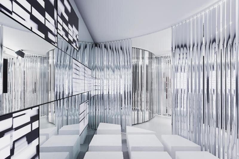
THE EXHIBIT
‘Past Futures, Present, Futures’ was a two part exhibit at Storefront for Art and Architecture in New York City designed by Leong Leong. The exhibit which ran from 10.06.12 - 11.24.12 and displayed unrealized visions for New York City by designers and visionaries throughout the cities history. The second phase of the exhibit invited a broad group of designers to revisit these ideas with fresh eyes. (Photo Credit: Naho Kubota)